HOEFNAGEL, GEORG: VIEW OF PETRINJA
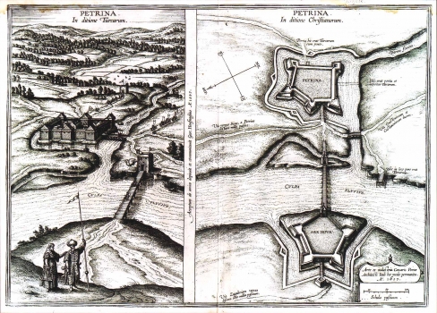
Hoefnagel's two views map of Petrinja was published in Braun's "Civitates Orbis Terrarum", in 1617. This two-view map shows Petrinja as it was during the Turkish rule, and then as it was after being recaptured and restructured. The first map depicts Turkish Petrinja after its reconstruction following one of the conflicts with the Christian army. In Turkish times Petrinja was set on an artificial islet in the river Petrinjũca. It had the shape of an irregular square, flanked with four quadrangular bastions. Two wooden bridges provided access to the fortress, one across the river Kupa and the other across Petrinjčica. After its liberation, Petrinja entered another period of reconstruction completed in 1617. The second map image shows the renewed fortress of Petrinja. After the reconstruction, the fortress acquired pentagonal form with four-sided bastions at each corner. Two newly constructed bridges provided access to the town form the west. There was a third bridge too, across Petrinjčica, in the vicinity of the confluence of Petrinjčica and Kupa. As it can be seen, on the left bank of Kupa, Turks built another fortress, called Husarski grad. The network of roads is also indicated: the main road connecting Petrinja and Zagreb, the second road leading from Petrinja to Sisak, and the third one form Petrinja to the nearby fortresses Hrastovica and Kostajnica. The fourth road leaded from the fortress to the old Turkish bridge destroyed during the reconstruction. On the backside of the map a narrative account of Petrinja is given.
HOEFNAGEL, GEORG
