HOMANN, JOHANN BAPTIST: MAP OF SLAVONIA AND SRIEM
Inventory number 255
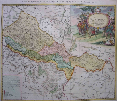
Original title: Tabula geographica exhibens Regnum Sclavoniae cum Syrmii Ducatu, ex mappa grandiori desumta et in lucem edita ab Homannianis Heredibus
Publishing year: 1745
Place of publishing and publisher: Nürnberg
Format: 48 x 46 cm
Technique: Coloured copper engraving
The map of the Kingdom of Slavonija and the Duchy of Sriem by Homann’s heirs shows the situation as it was after the Peace Treaty of Požarevac concluded in 1718. Coloured in green is the Border land of Posavina (Slavonian Generalte), with a narrow zone of Bosnian Posavina integrated following the Peace Treaty of Požarevac into the Habsburg Monarchy. In the civilian part of Slavonia, as well as in the area of Sriem, the outlines of feudal estates are indicated. The map is based on Khevenhüller’s great map showing the region of Slavonia after the Peace Treaty of Požarevac. This is a reduced-size copy of that map. The title of the map is in the upper right corner in a baroque cartouche containing the coat of arms of Bosnia. The cartouche is surrounded by Trenk’s hussars that, at the time of the creation of this map, participated, under the aegis of Mary Therese, in war campaigns in which the Autstrians were involved.
HOMANN, JOHANN BAPTIST
JOHANN BAPTIST HOMANN (1663-1724), a great German cartographer and editor. Thanks to Homann, the Cartography begun to be perceived in Germany as an independent scientific discipline. Homann collaborated with all the most prominent scientists of his time. In the period between 1702 and 1716 he incised over 100 copper printing plates with map designs. His workshop produced over 600 maps. His maps are seldom dated, so, it is difficult to establish their succession in time. Johann Baptist Homann's most famous works are as follows: "Atlas Novus", 1701, "Atlas von hundert Chartewn", 1712 and "Grosser Atlas über die ganze Welt" consisting of 126 maps. After his death, Michael Franz and Johann Georg Ebersberger had been directing his workshop's activity under firm-name Homannianos Heredes (Hommann's heirs) until the beginning of the 19th century.