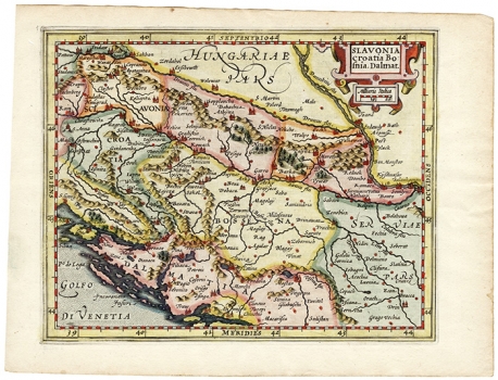
HONDIUS, JODOCUS: MAP OF SLAVONIA, CROATIA, BOSNIA AND A PART OF DALMATIA
Inventory number 388
Author: HONDIUS, JODOCUS
Original title: Slavonia, Croatia, Bosnia, Dalmat.
Publishing year: 1610
Place of publishing and publisher: Amsterdam
Format: 13,2 x 18,1 cm
Technique: Coloured copper engraving
The map is from one edition of the so-called Mercator-Hondius "Atlas Minor", which had many editions with very little changes and an increasing number of maps, and which, after the Hondius family, was released by Jan Jansson. The boundaries are drawn very arbitrarily, so that Slavonia divides and extends eastwards from Croatia, which is very narrow, while Dalmatia is deep in the hinterland. The same mistakes, of course, also appear in Mercator's large format (folio) maps. The map is decorated with a Baroque cartouche, and the scale is expressed in Italian miles.
HONDIUS, JODOCUS
After Ortelius' death, JOCODUS HONDIUS (1563-1611) continued his work. Hondius was a graphic artist and map publisher. He spent ten years in London where he was producing globe models. Around 1593/94 he went back to Amsterdam. In 1604 he bought Mercator's engraving plates, and in 1606 he finished his work on the first enlarged edition of the Atlas of Mercator to which he added 36 new maps. Until 1611 he published five more editions of this atlas (In 1607 the atlas was edited in Latin and in French, in 1608 in French and in 1611 in Latin). HENRICUS HONDIUS (1587-1637) succeded Jacodus Hondius and continued to publish Mercator-Hondius atlases.
