GOERÖG (GORÖG), DEMETER: THE DISTRIKT OF BROD
Inventory number 433
Author: GOERÖG (GORÖG), DEMETER
Original title: A Brodi Hatarorzo Regement
Publishing year: 1802 - 1811
Place of publishing and publisher: Wien
Format: 29 x 36 cm
Technique: Partially coloured lithograph
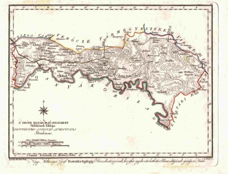
The map of the 2nd edition of "Magyar Atlas" shows the Brod Regiment, which together with Gradiška and Petrovaradin Regiment formed the Slavonic Military Frontier, which was not only a tactical but also a territorial and administrative unit. The Brod Regiment was located north of the Sava River, somewhat west of Slavonski Brod to a little east of Vinkovci, with which it is not connected by road. The Military Frontier was abolished in 1873 and incorporated in Croatia-Slavonia in 1881. The map shows the relief, i.e. the plains and the local wetlands, the road to Osijek and many toponyms.
GOERÖG (GORÖG), DEMETER
GOERÖG (GORÖG), DEMETER (1760-1833), a cartographer and manufacturer of globuses from Budapest. In 1789, with the financial support of Duke Miklos Eszterhazy, he opened his cartographic publishing house. His most famous work is Magyar Atlas, published in 1802 and again in 1841.
