GOERÖG (GORÖG), DEMETER: THE DISTRIKT OF GRADISKA
Inventory number 484
Author: GOERÖG (GORÖG), DEMETER
Original title: A Gradiskai Hatarorzo Regement
Publishing year: 1802 - 1811
Place of publishing and publisher: Wien
Format: 29,3 x 21,3 cm
Technique: Lithograph, partialy coloured boundary lines
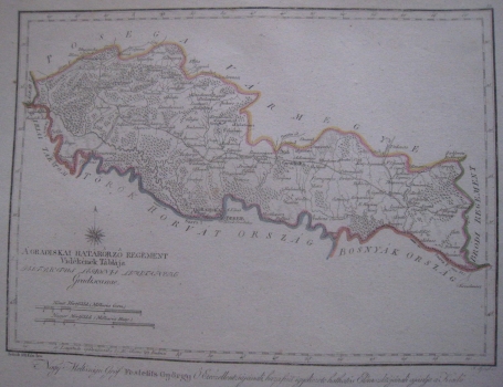
The map shows a very narrow area of the Military Frontier north of the Sava River from Jasenovac to Dubočac, which is surrounded in the north by the Požega County, in the west by the Zagreb County and in the east by the Brod Regiment. It is part of the Military Frontier because in the south, across the river Sava, it borders the so-called Turkish Croatia and Bosnia, still under Ottoman rule. It is evident that it is a flat and very afforested area. The well-preserved Stara Gradiška fortress on the River Sava is marked well and faces the Turkish side of the river with the fortress Berbir, which no longer exists. The map is dedicated to Count Đuro Feštetić (see previous map).
GOERÖG (GORÖG), DEMETER
GOERÖG (GORÖG), DEMETER (1760-1833), a cartographer and manufacturer of globuses from Budapest. In 1789, with the financial support of Duke Miklos Eszterhazy, he opened his cartographic publishing house. His most famous work is Magyar Atlas, published in 1802 and again in 1841.
