GOERÖG (GORÖG), DEMETER: THE DISTRICT OF VIROVITICA
Inventory number 488
Author: GOERÖG (GORÖG), DEMETER
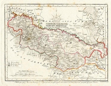
Original title: Verocze Varmegye (Comitatus Veroczensis)
Publishing year: 1802 - 1811
Place of publishing and publisher: Wien
Format: 22 x 29 cm
Technique: Lithograph, partialy coloured boundary lines
This map is one of the oldest in the atlas, engraved in 1799 and by many elements one of the most successful. At the same time, it is highly legible and rich in information. The Virovitica County covers the area south of the Drava River and north of the Požega County and the Brod Regiment. It is divided into three districts: Virovitica, Đakovo and Osijek. The map contains many toponyms, such as Virovitica, Orahovica, Našice, Osijek, Đakovo and Valpovo, as well as many smaller ones, such as Ćepin, Tenja, etc. The road network and the relief (Papuk) are visible. Great attention was paid to marking wetlands north of Našice, and especially north of Osijek, along the Drava and Danube (Kopački rit). The map is dedicated to Count Đuro Feštetić.
GOERÖG (GORÖG), DEMETER
GOERÖG (GORÖG), DEMETER (1760-1833), a cartographer and manufacturer of globuses from Budapest. In 1789, with the financial support of Duke Miklos Eszterhazy, he opened his cartographic publishing house. His most famous work is Magyar Atlas, published in 1802 and again in 1841.
