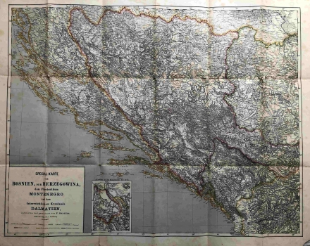
MAP OF BOSNIA, HERCEGOVINA, MONTENEGRO AND THE AUSTRIAN KINGDOM OF DALMATIA
This large overview map shows the synthesis of the 1878 Congress of Berlin, with the territorial division of the Balkan Peninsula, under which Bosnia belonged to the Habsburg Monarchy. Dalmatia is presented within the framework of a separate Austrian crown land. Both former Ottoman corridors, the first near Neum and the second near Sutorina, were retained in the new division which is marked on the map with colour. Traffic communications are particularly emphasized. The title graphic scale cartouche is located in the bottom left corner, and next to it is a segment of a map of Mitrovica and Vučitrn in Kosovo. In the north, Dalmatia borders the Military Frontier, and the toponyms were likely taken from templates in the Italian language, as the language was used to mark a part of the site, especially on the islands. Other similar maps from the same era, such as the Flemming maps, record military engineering topographic data and methods. The map was published in collaboration with Carl Flemming as the publisher.
HANDTKE, FRIEDRICH
