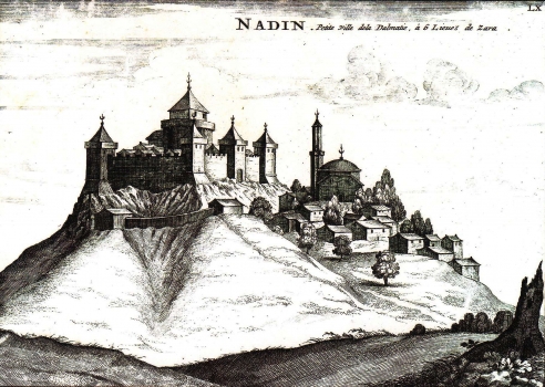
MORTIER, PIERRE: VIEW OF THE TOWN OF NADIN
This Mortier’s view of Nadin is an unchanged issue of the map first appeared in Coronelli’s atlas “Isolario dell Atlante Veneto”. It was published by Mortier in his atlas of 1704, on page marked LX. The map depicts Nadin, today a small place in Zadar hinterland. The settlement was captured by Turks in 1538 and stayed under their control until 1684. Mortier's view of Nadin features the town as it was during the Turkish rule. The stronghold had the shape of a rectangular fortress provided with square towers at the angles. The fortress was accessed through the gatehouse. Within the walls stood a massive bastion with an observatory balcony set around to keep an eye on the surrounding area. Only a small number of dwelling houses were built within the space enclosed by the walls. The greater part of domestic houses was situated outside the walls at the foot of the fortress together with an imposing mosque.
MORTIER, PIERRE
