MORTIER, PIERRE: PLAN OF SPLIT
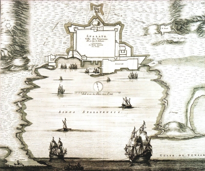
This plan of Split from 1695 was published in the "Noveau Theatre de l'Italy" atlas in 1724. It is the 1695 edition of Mortier's plan (Mortier published the first release in his atlas "Le Théâtre de la guerre" in 1702). Although the plan is obviously based on templates of its cartographic predecessors, Santini and Coronelli, it contains many inaccuracies. The centre of attention is the display of the town's fortification, the fortress of Gripe and the port of Lazaret. The entire city is shown as a straight rectangle without starry fortifications., Additional errors have occurred due to such representation. The Dominican monastery and its church were misplaced within the city's ramparts. The Lazaret buildings in the harbour do not respond to their actual condition. The representation of the Botticelli Fortress in Bačvice is unfinished. Nevertheless, the plan is interesting because it displays Split before the Srijemski Karlovci Peace (1699), when the city was still a part of the Turks' direct danger. This also explains many omissions. Namely, the map’s purpose was not military, but most likely quite informative - to point out the defensive power of Split to the European public. The title of the map is located inside the city walls.
MORTIER, PIERRE
