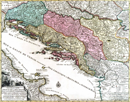
OTTENS: MAP OF THE KINGDOM OF DALMATIA
This map is a kind of compilation of the maps made by Coronelli, Rossi and Nolin. It was published in the atlas of brothers Ottens in Amsterdam, most probably in their "Atlas Major" of 1745. The map depicts all of the Croatian lands except for Istria showing their administrative-unit division. The boundaries, the same as the administrative units featured roughly show the medieval territorial organization pre-existing the Turkish invasion. So, in the region of Slavonia the counties of Požega and Valpovo are delineated, as well as "Mala Vlaška", in the area of Pakrac, and the Duchy of Srijem. In the Croatian territory south to the river Sava the rivers Gacka, Lika, Krbava and "Caribasa" are shown in the area around Lapac, and Morlakija flowing through the Velebit area. Dalmatia comprises the medieval counties of Nin, Sidraga, Knin, Livno, Imotski and Paratalassia. As is usual with most Venetian maps, Dalmatia includes the whole Herzegovina. The representation of Dalmatian borders is not based on facts, it rather expresses the attitude of the Venetians as regards the proper position of their border with the Turkish Empire. A mileage scale is expressed in Italian, Hungarian, German and Turkish miles and it is featured in the lower left corner of the map in a cartouche toped by the Venetian Lion and a Turkish soldier with the Ottoman shield in the background. In the lower right corner of the map a signature of the engraver O. Lindeman is placed.
OTTENS, JOACHIM
