MORTIER, PIERRE: THREE CARTOGRAPHIC REPRESENTATIONS OF KLIS
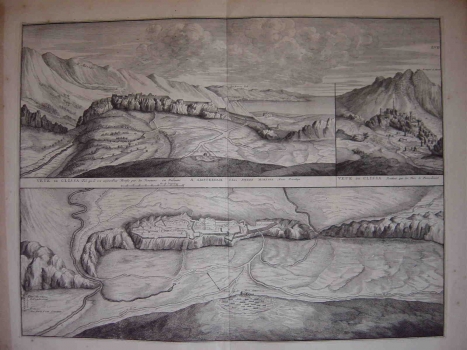
In the year 1704 the Dutch publisher Pierre Mortier issued a big map of Italian and Dalmatian town view engravings comprising the map of Klis. This graphical folio contains three map images of Klis – two views and one plan. All the three are inspired by the event occurred during the Candian Venetian-Turkish war when in 1648 the Venetians wrested from the Turks the strategically important fortress of Klis. The first view titled “Veue de Clissa tel qu il est aujordhy Fortific par les Venetiens en Dalmatie” shows Klis as it was already under Venetian rule, as seen from its northern side, i.e. from the side of the Ottoman border (it is marked on the map by guard-house symbol). In the inland zone the mountain range of Mosor is represented pictorially. The intention of the author was to highlight the strategic importance of the geographical position of the fortress of Klis, one of the most important Venetian strongholds in Dalmatia. The second view titled "Vue de Clissa pentant que les Turc le Posedonent” shows the fortress and the settlement of Knin as it was while forming part of the Ottoman Empire. In the settlement shown the dominant feature, besides the fortress, is the mosque provided with a tall minaret. The third map shows the system of walls and defence forts of the fortress of Klis after their reconstruction carried out in the course of the 17th century, while under Venetian rule. Around the fortress the roads are also shown amongst them the road leading to Split and Trogir, and to the north of the fortress, the border markings and the Turkish military camp can be seen.
MORTIER, PIERRE
