MORTIER, PIERRE: PLAN OF ZADAR
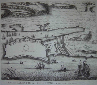
Mortier's plan of Zadar was included in the work “Noveau Theatre de l’ Italie” published in 1724 by the Dutch publisher Rutger Christopher Alberts. Mortier plan was based on one almost identical map image of the city fortifications made by Coronelli and published in the “Isolario dell Atlante Veneto”. The plan shows the fortification system of the town of Zadar, the biggest and the most important Venetian fortress on the Eastern Adriatic. In the water front mighty Venetian ships guarding the entrance to the town can be seen. The fortifications of Zadar of the Venetian period are a classical example of the fortification system that, on the landward side and along the narrow port were formed by thick curtain walls and seven large bastions, and towards the sea by less thick walls provided with three smaller bastions. The hinterland is shown schematically and the geographical features are represented as shaded molehills (gentleman’s method) in semi-bird’s eye view (relief as though viewed from a higher position of the so called gentleman).
MORTIER, PIERRE
