ORTELIUS, ABRAHAM: MAP OF PANNONIA AND ILLYRICUM
Inventory number 234
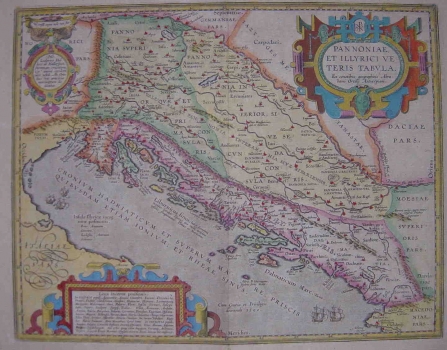
Original title: Pannoniae et Illyrici Veteris Tabula
Publishing year: 1609
Place of publishing and publisher: Antwerpen
Format: 36 x 46 cm
Technique: Coloured copper engraving
The map of Pannonia and Illirya is one of the rare maps bearing autograph signature of Abraham Ortelius. In fact, more than as author, this famous Dutch was noted as collector and publisher of maps made by other authors, which he published in various editions of his famous atlas «Thetrum Orbis Terrarum». The map of Pannonia and Illyria by Ortelius showing the area in classical times was included in the first edition of Ortelius's Atlas of 1570, and this example was published, after Ortelius’s death, by Robert Bruneau, in Antwerp, in 1609. The map was based on information from ancient sources, specifically Strabo, Pliny and Antoninus. It shows the Roman Illyricum with the delineation of administrative units as established by the Emperor Diocletian during the reorganization of the Empire carried out in 297. Interesting to note that along the map’s margin Ortelius included the list of places of uncertain location. The title of the map is in a late Renaissance cartouche placed in the upper right corner, while the list of place names is in the lower left corner.
ORTELIUS, ABRAHAM
BRAHAM ORTELIUS (1527-1598), a 16th-century geographer and cartographer from Antwerp. He is the foremost Dutch cartographer of all times. After he studied engraving and cartography techniques, for a while he had made a living as a map illustrator. Yet, he made relatively small number of maps of his own. Today, only five maps are firmly recognized as personally drawn by him. The significance of Ortelius' work resides primarily in his efficiency at collecting of cartographic materials and in his atlas-making activities. Up to the year 1570 he gathered 70 maps, that he bound to form a book of the "Theatrum Orbis Terrarum", considered the world's first atlas in the modern sense. His atlas consisted of the maps produced by him or by other cartographers drawn upon various sources. On each map Ortelius identified the author of the map used as model, or the source the map was based upon. To the maps of the "Theatrum" the "Catalogus Auctorum" was appended, which is a list with the names of the cartographers known to him (87 names) and their works. Ortelius' atlas drew a great attention comparable only to the success that had Ptolemy's Geography. The "Theatrum Orbis Terrarum" went through 41 editions. How great Ortelius' reputation established by the success of his atlas was, can be seen from the fact that in 1575 he was designated royal geographer of Phillip II of Spain. Likewise Ptolemy's work, the "Theatrum" was enlarged in subsequent years trough the addition of new maps (the Additamenta").