MORTIER, PIERRE: PLAN OF THE FORTIFICATIONS OF TROGIR
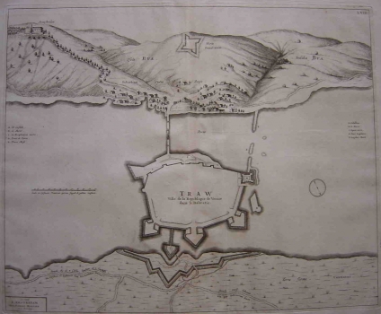
The plan of the fortifications of Trogir was published in Mortier’s atlas “La Theatre de la guerra”. This plan of Trogir was in circulation already in 1695. Compared to earlier views of Trogir (Coronelli) considerable changes can be seen. On the landward side, the island on which Trogir is situated was protected by three massive bastions. The fort of St. Anna was separated from it by means of a sea channel cut trough. From the kaštel to Čiovo a long stone pier was built with the opening for enter and leave sailings. The port was closed in the eastern side by the drawbridge towards the island of Čiovo. The urban structure of the town is not identified as this is a classical fortification plan showing exclusively defense structures of the town. On Čiovo next to the bridge the homonym settlement can be seen, in expansion in those days. The rector of Trogir had there his palace. On top of a hill above the village the people of Trogir have risen a smaller fortification to guard the port of Trogir. The map is south oriented. A mileage scale is given in Venetian foots.
MORTIER, PIERRE
