MORTIER, PIERRE: VIEW OF SENJ AND OBROVAC
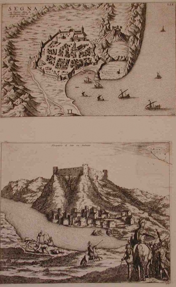
ad a) This view of Senj based on similar views included in some of the editions of Venetians isolarios, was published in Mortier’s atlas of 1704. The town of Senj, at the time of production of this view was the seat of the Senj captaincy and the principal border-land fortress on the coast. On the view it is shown as a fortified settlement enclosed by walls of medium thickness in the form of an irregular quadrangle provided with 11 round mural towers, round towers and square towers. On the western side the city wall begun from the tower of Turina. From there the wall continued to the tower of Ambroz and Pope’s tower up to the towers Tribenac and Salapanok. The northern extremity of the walls was formed by the jutting bastion Gulden. From there the walls descend southwards up to the Kaštel which comprised two angular semi integrated towers and one round tower called Philip’s tower. From the Philip’s tower the walls continued to the tower Naša and Šabac that protected St. Mary’s church. The port bastion (Pastein) protected the southern wall facing the sea and Sea gates. In the vicinity of the Great gates stands the fort of Kaštel, dwelling-place of Senj’s rectors and captains. That massive fort provided with four angular towers was erected around 1310 by princes of Krk. Later on, Kaštel served to the Frankopans as their Senj residence and after 1469 it became a fortification and the seat of the commander of the Captaincy. Inside the walls housing structures and gardens of Senj can be seen. The only building identified outside the walls is the church of St. Mary on Art. In 1558, General Lenković built on the elevation named Trbušnjak a strong fortress - Nehaj, still today one of the most recognizable symbols of the town of Senj.
ad b) A picturesque town-fortress on the river Zrmanja, often included in various Venetian islarios. This view comes from Mortier’s atlas. In 1537, Obrovac was captured by the Tursks to stay in their hold until 1647. After it was retaken by the Venetians in 1647, the fortifications of Obrovac were reconstructed. This view shows Obrovac as it was under Turkish rule. The evidence of that is the symbol of crescent on one of the town buildings, that obviously had the function of a mosque. The town consisted of the fortress on top of a hill and the civilian part of the settlement which is also fortified by somewhat less thick walls. The town was provided by two gates: land gates and river gates facing Zrmanja. The old fortress above the town and the rests of the walls that encircled it can still be seen. In the foreground, soldiers watching the town are shown. It seems likely that this is Venetian general Foscolo during preparations to regain Obrovac that happened in 1647.
MORTIER, PIERRE
