MORTIER, PIERRE: VIEW OF KARLOBAG AND KNIN
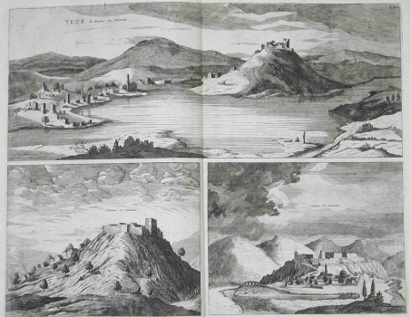
The first one of the three Mortier’s views shows Karlobag. The medieval Karlobag was in possession of the princes of Krbava. It comprised the fortress on the slope mentioned in documents as Scrissa (Vidovgrad) and the fortified settlement built beside seashore named Bag. In 1525, it was reduced to ruins by the Turks. In 1579, the settlement was reconstructed by the Archeduke Karlo for whom Karlobag was named, in 1580. Soon afterwards the town was recaptured by the Venetians who inflicted additional damages to it and, after that event, stayed in bad repair until 1672 when it was reconstructed. On this Mortier’s view the town can be seen as it was at the beginning of the reconstruction. The second Mortier’s view shows the fortress of Knin with its suburb as if seen from the southern side. The third view (lower right corner) shows Knin as it was under Turkish rule. It is based on a similar view by Vincenzo Maria Coronelli of 1684. The Turkish fortress on the mount Sveti Spas (St. Salvation) comprised the older kaštel (Castello Tapana) and the Turkish fortress set further north. The city wall descended from the fortress to the suburb encircling the whole of the mount of Sveti Spas. The fortress was provided with its own walls and towers. The suburb extended to the plain of Knin laying within the area of flooding of the river Krka. The fortress was accessed from its east side from the suburb. Within the fortified settlement three mosques can be seen. In 1688, the Venetians took Knin which remained under their control up to the fall of the Republic of Venetia occurred in 1797 as one of the most important land strongholds.
MORTIER, PIERRE
