ORTELIUS, ABRAHAM: MAP OF SLAVONIA, CROATIA, CARNIOLA, ISTRIA AND BOSNIA
Inventory number 276
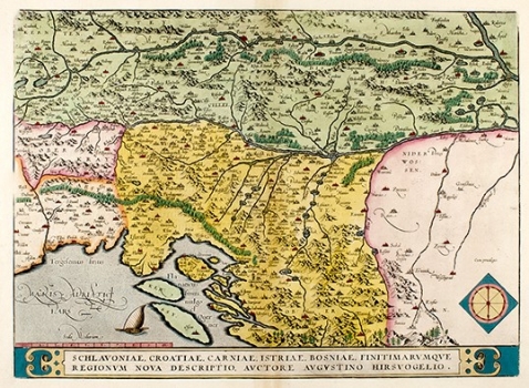
Original title: Schlavoniae, Croatiae, Carniae, Histriae, Bosniae finitimarumque regionum nova descriptio/ aucrtore Augustino Hirsvogelio
Publishing year: 1603
Place of publishing and publisher: Antwerpen
Format: 33,5 x 46 cm
Technique:
This map by Augustin Hirshvogel was issued in the Ortelius' "Theatrum". As regards the Croatian lands it shows the medieval outline of Slavonia and Croatia. This Hirschvogel's map was based on Lazarus's map of Hungary published in 1528. Their similarity can be clearly seen from the representation of the hydrographic system. In Slavonija major forests are indicated. The topography of the mount of Velebit with its rocky peaks forms a pretty scene. The fact that Bosnia, whose large parts had already been conquered by the Ottomans, was for Hirschvogel "terra incognita" can be seen from the absence of indications but a few place names in the whole Bosnia, leaving the emptiness of this territory contrast with the other parts of the map. The title of the maps is in a rectangle panel cartouche across the lower map's margin. In the lower left corner is a mileage scale in miles (Scala Milliaria). See also map no. 60.
ORTELIUS, ABRAHAM
BRAHAM ORTELIUS (1527-1598), a 16th-century geographer and cartographer from Antwerp. He is the foremost Dutch cartographer of all times. After he studied engraving and cartography techniques, for a while he had made a living as a map illustrator. Yet, he made relatively small number of maps of his own. Today, only five maps are firmly recognized as personally drawn by him. The significance of Ortelius' work resides primarily in his efficiency at collecting of cartographic materials and in his atlas-making activities. Up to the year 1570 he gathered 70 maps, that he bound to form a book of the "Theatrum Orbis Terrarum", considered the world's first atlas in the modern sense. His atlas consisted of the maps produced by him or by other cartographers drawn upon various sources. On each map Ortelius identified the author of the map used as model, or the source the map was based upon. To the maps of the "Theatrum" the "Catalogus Auctorum" was appended, which is a list with the names of the cartographers known to him (87 names) and their works. Ortelius' atlas drew a great attention comparable only to the success that had Ptolemy's Geography. The "Theatrum Orbis Terrarum" went through 41 editions. How great Ortelius' reputation established by the success of his atlas was, can be seen from the fact that in 1575 he was designated royal geographer of Phillip II of Spain. Likewise Ptolemy's work, the "Theatrum" was enlarged in subsequent years trough the addition of new maps (the Additamenta").