MÜNSTER, SEBASTIAN: MAP OF ILLYRICUM
Inventory number 73
Author: MÜNSTER, SEBASTIAN
Original title: Descriptio totius Illyridis XVI Nova Tabula
Publishing year: 1552
Place of publishing and publisher: Basel
Format: 28 x 37 cm
Technique: Wood-cut
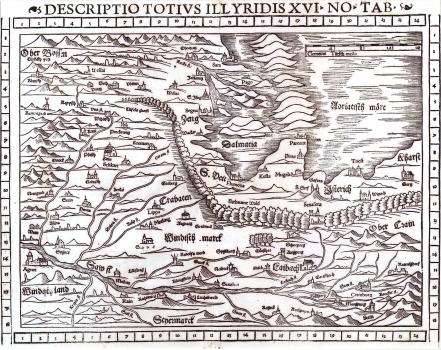
The first release of this map was published in the first Münster's edition of Ptolemy's Geography in 1545. This map was also published in the last issue of Ptolemy's Geography edited by Münster in Basel in 1552. Münster's map of Illyricum is one of the first printed maps of the Croatian lands. The map shows a part of medieval Croatia and Slavonia. There is no indication of borders, so, the territories are detected only through the names marked on them. Turkish settlements are marked by a crescent. The title is above upper margin edge. The map is south orientated. A mileage key is in German miles.
MÜNSTER, SEBASTIAN
MÜNSTER, SEBASTIAN (1489-1552), a German geographer and cartographer. He was a professor of cosmography in Bern. His most well-known work, Cosmographia, was published in 1544 and it had 24 editions. He was the editor of several editions of Ptolemy's Geographia (1540, 1541, 1542, 1545, 1551, and 1552).
