MEISNER, DANIEL: VIEW OF PETRINJA
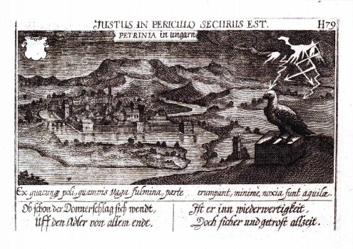
This map image is based on two examples made by J. Oertel in 1602. After this redrawn some other were derived from it, during the first half of the 17th century. At that time Petrinja had an exceptional strategic importance for the defense of Croatia from the Turks. After they took the town in 1592, pasha Hasan built the fortress that appears on this map on the confluence of the rivers Petrinja and Kupa. Meisner's view represents Petrinja after its liberation (1596) and rejecting of the Turks toward the river Una. At the time this maps was produced, Petrinja was one of the key fortresses in the system of defense organized by the Habsburgs - a fact that is clearly visible in this engraving. The map shows the fromer Turkish settlement of rectangle shape. The moat surrounding the fortress was filled with water of the river Petrinja. In the foreground, the fortification walls are shown with massive bulwarks suggesting their great defensive power. The eagle sitting on the rock above Petrinja represents the Monarchy of Habsburg. The map includes in its lower part a baroque sentence written in elegiac couplets: Ex quacunque poli, quamvis vaga fulmina, parte/Erumpant, minime, noxia sunt aquilae. In translation: Although the flashes of lightning are striking from the sky / the Eagle won't be endangered by them, or suffer any harm. The text that follows is the Latin sentence paraphrased in German: Ob schon der Donnerschlag sich wendt,/ uff den adler von allem endt./Ist er inn weiderwertigheit,/Doch ficher und getroft allzeit.
MEISNER, DANIEL
