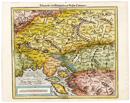
MÜNSTER, SEBASTIAN: MAP OF SLAVONIA, WINDISCH MARK, BOSNIA AND CROATIA
This Münster’s map was published in one of the editions of his «Cosmographie», published in Basel around 1580. Along with the Carniolan and Slovenian mark (Windisch Mark), the map shows Croatia within its historic boundaries reaching as far as the river Vrbas, and the west part of that time Slavonia. The map was based on one almost identical map image issued in 570 by Augustin Hirschvogel. The relief is shown with shaded molehills. Especially interesting is the representation of the vegetation in the Kvarner hinterland shown as markedly wooded area. The coastal lines are featured with many inaccuracies. This is especially revealed in the representation of the islands of Cresa (Kers) and Lošinj (Sy), whose contours are hardly recognizable. The title is along the upper edge of the map’s margin.
MÜNSTER, SEBASTIAN
