NOLIN, JEAN BAPTISTE: MAP OF DALMATIA
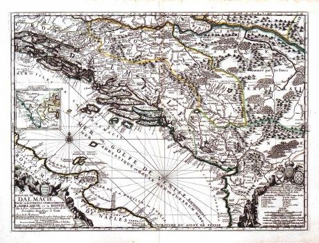
On the map of the kingdom of Dalmatia the whole province of Dalmatia is shown, together with the Republic of Dubrovnik, Bosnia and parts of Croatia. Within Dalmatia that inaccurately comprises the whole Herzegovina, the delineation is made of administrative unit boundaries whose designation is also doubtful. Along the left map's margin is included a supplementary map representing Istria with Gulf of Kvarner both showing large deformations. In the map's lower right corner there are coats of arms of Bosnia, Dalmatia with a crown and the blazon of Croatia. In the lower left corner of the map the title is shown, surrounded with military insignia, a lion (symbol of Venice) and the coat of arms of the Republic of Dubrovnik. The engraver incised his signature along the lower margin edge reading: "J Guerard fecit". A mileage scale is expressed in Italian, Hungarian, French and nautical miles.
NOLIN, JEAN BAPTISTE
