MONTECALERIO (MONTE CALERIO), JOANNIS: MAP OF STYRIA AND PART OF CROATIA
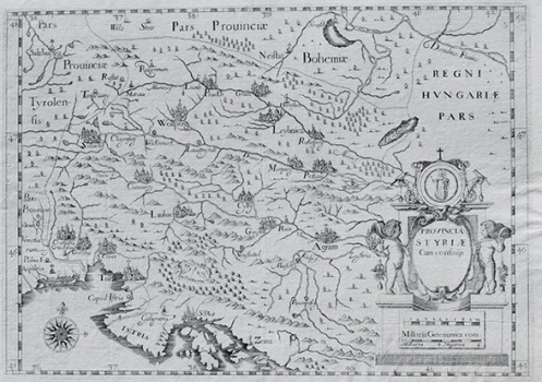
This map depicts the Duchy of Styria, as well as neighboring Istria and the Croatian lands to Zagreb (Agram) to the east and Croatian Littoral in the southeast. The further neighborhood is made up of parts of Bohemia, Hungary and Tyrol. The western and northern borders of Styria are marked with a dotted line. The eastern border is depicted on Lake Balaton (Lac de Balaton). Orographic content is simplified and shown as schematic sketches, similar to vegetation and hydrographic network. The most important cities (Villach, Goritia, Triest, Laubac, Wolfperg, Graiz, Rakersperg, Petaw, Cylly, Agram) are drawn in small perspectives and at the same time as templated views. Interestingly, the map repeats an error by Mercator, namely the double location of Zagreb (once labeled as Agram, and second time as Zagreb). The geographic coordinats are marked around the map frame, and in the lower right corner there is a baroque cartouche with religious symbols of patrons, paths, floral motifs and graphic scales expressed in German and Hungarian miles. The map is very similar to Sanson's half a century older charts, which were much more precise in the line of delimitation in Istria between Venetian and Austrian possessions. The Istrian interior and the coastal line of the peninsula are more accurately depicted on them. Similar charts were released later in the atlases of Sanson's heir Jaillot until 1712, and the same territoy was also mapped by Homann. Although this map is rich in topography, distortion and weaker knowledge of the Istrian land reminds us of the earlier work of Mercator from his Cosmographiae. Croatian countries are simplified, partly because they are not the primary focus of the author, who obviously knows them very superficially. Similar intolerance for coastal belts such as Istria and the Kvarner Coast was intensified using bad templates, which is particularly noticeable in contours of the Istrian peninsula.
MONTECALERIO, JOANNIS (GIOVANNI)
