MOLLO, TRANQUILLO: SLOVENIA AND CROATIA
Inventory number 366
Author: MOLLO, TRANQUILLO
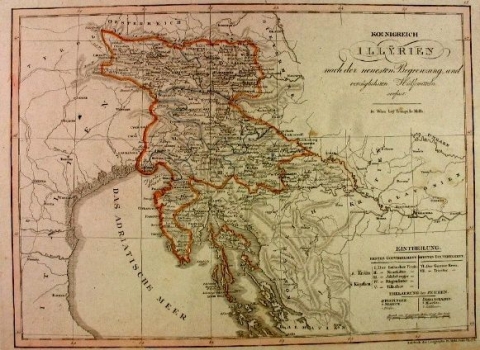
Original title: Koenigreich Illyrien nach der neuesten Begrenzung und vorzüglichsten Hülfsmitteln verfast
Publishing year: 1824
Place of publishing and publisher: Wien
Format: 32,5 x 44,5 cm
Technique: Litograph
The map is centred on Slovenia, after the Vienna Peace from 1814-1815, which from the part of the Napoleonic Illyrian Provinces Austria has administratively organized the Kingdom of Illyria from 1816 to 1849. According to the first structure, Kranjska and Carinthia were divided into five districts, to which two further were added, of which the Trieste district (VII) occupies the entire western part of Istria. The Croatian border towards Bosnia passes through the rivers Una and Korana and at Dubica it connects with Sava River. Considering that in Croatia, which is not a subject of the map, there are not many toponyms, the relief is more emphasized, which is shown by shading, especially Velebit.
MOLLO, TRANQUILLO
MOLLO, TRANQUILLO (most productive period: 1800-1837), a Viennese engraver, printer and publisher of art editions, including music. His maps were drawn and engraved by Josef Ignaz Gurk (most productive period: 1795-1826) and his son Eduard Gurk (who worked from 1801 to 1841). Mollo collaborated with and published for Sotzman in 1812 and N. Dirwald (America was published in 1823). In addition to this, his most significant works were Teutschland from 1800, Turkai from 1808, Bohemien & Galicien from 1809 and Austria from 1816. He was succeeded by his son EDWARD MOLLO (1797-1842), an engraver and publisher.
