MOLLO, TRANQUILLO: CROATIA
Inventory number 367
Author: MOLLO, TRANQUILLO
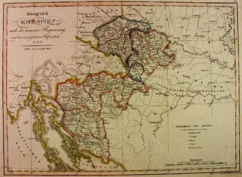
Original title: Königreich Kroatien
Publishing year: 1824
Place of publishing and publisher: Wien
Format: 32,5 x 44,5 cm
Technique: Lithograph, partialy coloured boundary lines
The map shows the administrative division of the Croatian Military Border, whose territorial divisions and administrative units changed names and organization permanently during the 17th and 18th centuries, so different names were used on the map, such as regiments, counties, districts, etc. The whole "civilian" Croatia is squeezed into space between Zagreb and Varaždin, and the rest, without Slavonia, Dalmatia, Primorje and Istria, is depicted as the Military Border.
MOLLO, TRANQUILLO
MOLLO, TRANQUILLO (most productive period: 1800-1837), a Viennese engraver, printer and publisher of art editions, including music. His maps were drawn and engraved by Josef Ignaz Gurk (most productive period: 1795-1826) and his son Eduard Gurk (who worked from 1801 to 1841). Mollo collaborated with and published for Sotzman in 1812 and N. Dirwald (America was published in 1823). In addition to this, his most significant works were Teutschland from 1800, Turkai from 1808, Bohemien & Galicien from 1809 and Austria from 1816. He was succeeded by his son EDWARD MOLLO (1797-1842), an engraver and publisher.
