MOLLO, TRANQUILLO: SLAVONIA
Inventory number 369
Author: MOLLO, TRANQUILLO
Original title: Koenigreich Slavonien
Publishing year: 1824
Place of publishing and publisher: Wien
Format: 32,5 x 44,5 cm
Technique: Lithograph, partialy coloured boundary lines
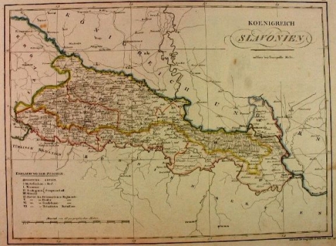
The map shows Slavonia, which is located between the Sava River, the Drava River and the Danube River and to the west to the Ilova River. The Military Border stands out in the map. It extends to the north of the Sava River, along the entire border with Turkish Croatia, Bosnia and Serbia to Novi Sad, i.e. Petrovaradin. Rivers, roads and shaded relief, which is most prominent in the area of Fruška Mountain, are indicated in the map.
MOLLO, TRANQUILLO
MOLLO, TRANQUILLO (most productive period: 1800-1837), a Viennese engraver, printer and publisher of art editions, including music. His maps were drawn and engraved by Josef Ignaz Gurk (most productive period: 1795-1826) and his son Eduard Gurk (who worked from 1801 to 1841). Mollo collaborated with and published for Sotzman in 1812 and N. Dirwald (America was published in 1823). In addition to this, his most significant works were Teutschland from 1800, Turkai from 1808, Bohemien & Galicien from 1809 and Austria from 1816. He was succeeded by his son EDWARD MOLLO (1797-1842), an engraver and publisher.
