MOLLO, TRANQUILLO: DALMATIA
Inventory number 368
Author: MOLLO, TRANQUILLO
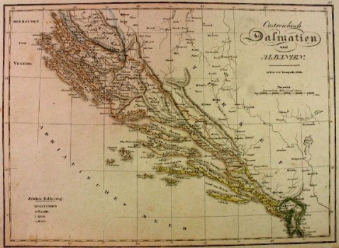
Original title: Oesterreichisch Dalmatien und Albanien
Publishing year: 1824
Place of publishing and publisher: Wien
Format: 32,5 x 44,5 cm
Technique: Lithograph, partialy coloured boundary lines
The map shows the situation after the Vienna Peace of 1815/16 where Dalmatia from the island of Pag to Kotor, including the former Republic of Dubrovnik, was ruled by Austrians. Although it was originally divided into four districts (Zadar, Split, Dubrovnik and Kotor), it was soon proclaimed the Kingdom of Dalmatia, even though the map is not named as such. Also, on the map, the entire Gulf of Kotor is markedly indicated as Albania, which is completely wrong, because Kotor at that time was a significant Austrian war harbour. The relief, shown by shading, is quite credible.
MOLLO, TRANQUILLO
MOLLO, TRANQUILLO (most productive period: 1800-1837), a Viennese engraver, printer and publisher of art editions, including music. His maps were drawn and engraved by Josef Ignaz Gurk (most productive period: 1795-1826) and his son Eduard Gurk (who worked from 1801 to 1841). Mollo collaborated with and published for Sotzman in 1812 and N. Dirwald (America was published in 1823). In addition to this, his most significant works were Teutschland from 1800, Turkai from 1808, Bohemien & Galicien from 1809 and Austria from 1816. He was succeeded by his son EDWARD MOLLO (1797-1842), an engraver and publisher.
