Hrvatski Deutsch English
Home Maps Authors k-o OTTENS Novissima Tabula Hungariae et Regionum ei unitarum
OTTENS: MAP OF SOUTHEASTERN EUROPE

OTTENS: MAP OF SOUTHEASTERN EUROPE

Inventory number 437
Original title: Novissima Tabula Hungariae et Regionum quondam ei unitarum ut Transilvaniae, Valachiae, Moldaviae, Serviae, Romaniae, Bulgariae, Bessarabiae, Croatiae, Bosniae, Dalmatiae, Slavoniae, Morlachiae et Republicae Ragusinae
Publishing year: 1725
Place of publishing and publisher: Amsterdam
Format: 50 x 70 cm
Technique: Coloured copper engraving

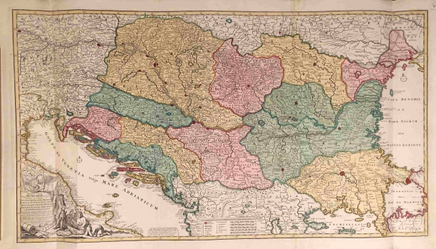
The Ottens brothers' map shows the area from Istria to the Black Sea. Although it is printed on two plates, it covers an oversized area not abounded with toponyms and other data (e.g. the relief is completely ignored). It is in fact a political map, where most attention is devoted to borders, which are particularly well-marked. Both format and content of the map are very similar to de Wit's and Valk's maps. The territory of Croatia is divided into Slavonia, which is located between Sava and Drava, from Belgrade to the Sutla River, so it includes Zagreb, Zagorje and Međimurje, then Croatia, which is south of Sava and includes the area from the eastern coast of Istria to Primorje to the south and almost to Jajce in the east, and to the great Dalmatia with Herzegovina, which goes north almost to Sarajevo, which is moved much more toward north than it actually is. Bosnia is therefore intertwined between increased Dalmatia and the Sava River, but the Drina river is moved toward east, so Bosnia occupies much of Central and Southern Serbia, Kosovo and a good part of Macedonia. It is interesting that the hinterland of Primorje includesa separate territorial unit of Morlakia, which is going to arouse European imagination only fifty years later in the work of Alberto Fortis.

OTTENS, JOACHIM
OTTENS FAMILY, publishers from Amsterdam. JOACHIM OTTENS (1663-1722), a founder of the workshop, a copper-plate engraver and publisher. His most well-known work is Austria from 1720. His workshop and shop of publishing art was inherited by his wife and sons. REINIER OTTENS (who died in 1750), and JOSHUA OTTENS (1726- 1766) were mapmakers and publishers, and sold maps and books. Their most well-known works are Mer Caspia from 1723, Copenhagen from 1728, Pocket Atlas from 1723, Atlas de Navigation from 1739 and Atlas Maior, published in 1745. Joshua Ottens was succeeded by his wife. In the 18th century, FREDERICK OTTENS made plates and maps for Velentyn’s publication Oost Indien and Marsigli’s Danube. His successors published N. America in 1755, Guerre en Amérique around 1760 and St. Eustatius in 1775.
Print Friendly and PDF
Top