MONATH, PETER CONRAD: ILLYRICUM
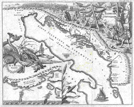
The map is printed in the 3rd part of the book "Scriptores rerum Hungaricum ... ", which presents a collection of valuable old historical texts in the choice of book editor, historian J.G. Schwandtner. Since the book also contains the complete text "De Regno Dalmatiae et Croatiae", by the founder of Croatian scientific historiography, Johannes Lucius, which was originally printed in Amsterdam in 1666 in the printing office of J. Blaeu and equipped with six maps, the book's editors, Matija Bel and J. G. Schwandtner decided to equip their book with six maps, too. He entrusted this work to famous publisher and cartographer Conrad Monath from Nuremberg who had previously published several books on Dalmatia and equipped them with maps and city views. One of these maps was published by Monath in 1718 in Reusch's book "Alter und neuen Staat des Königreichs Dalmatien" and is already in the catalogue of the Collection entitled "Dalmatia et regiones adjecentes ..." (No. 212). The map is the 6th map in the Schwandtner's edition of Lucius's book. This is the map "Illyricum Hodiernum", known for Blaeu's dedication to Petar Zrinski and later published in his "Atlas Maior". This map is also a part of the Collection (No. 211). This map in the Schwandtner edition of Lucius's book is the VIth map Illyricum Hodiernum, which is known for Blaeu's dedication to Petar Zrinski and later published in his atlas Atlas Maior. This map is also a part of the collection (No. 211). Monath decided to make his maps much more decorative, unlike Lucius / Blaeu's scientific historically and relatively sparingly maps, . So, the first map, originally called Illyricum et Liburnia, Tabula prima, and at Monath Illyricum Antiquum, was decorated with attractive views, depicting Illyrians, the pre-Roman inhabitants, war scenes, probably battles between Illyrians and Romans, but also a very decorative view of "seafood", i.e. fish and lobster, and ships. An enlarged part of Lucius's coast around Trogir with the islands of Čiovo, Šolta and Drvenik is in the lower left corner, represented in detail and in a special frame. This small map is called the peninsula of Hyllis in the original, though it is usually attributed to Pelješac.
MONATH, PETER CONRAD
