MONATH, PETER CONRAD: ILLYRIAN KINGDOM
Inventory number 427
Author: MONATH, PETER CONRAD
Original title: Regnum Illyricum cum Illyrico a Romanis addito
Publishing year: 1748
Place of publishing and publisher: Wien / Nürnberg
Format: 29 x 36 cm
Technique: Copper engraving
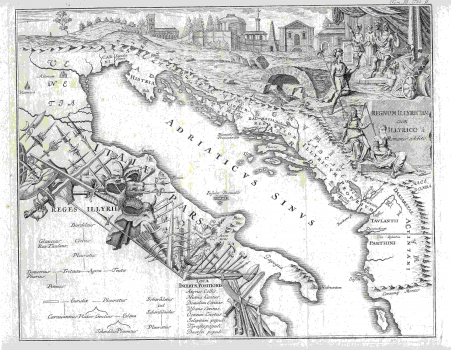
The second map, which in its original version is called "Regnum Illyricum et Illyricum a Romanis additum. Tab. Secunda" depicts Illyricum at the time when it was governed by the Romans. Geographically, it is naturally the same as the first map with an unbroken mountain chain stretching along the coast from Istria to today's Albania (the same as on the original map), but it is visually perhaps even more spectacular. There are numerous weapons over the Italian territory symbolizing Roman military power, while the upper part of the map occupies the view of various Roman buildings and Roman rulers surrounded by vassals. The genealogical table of Illyrian kings is situated in the lower left corner, as in the original map.
MONATH, PETER CONRAD
MONATH, PETER CONRAD (1682-1747), a polyhistorian, cartographer and publisher from Nuremberg, who later moved to Vienna. He specialized in the works of astronomy and mathematics. Together with Johann Gabriel Doppelmayr and Johann Georg Puschner, he also sold globes in the Vienna branch of his bookstore. His most well-known works are Grundriss Belgrad from 1717 and Dalmatien from 1718.
