MONATH, PETER CONRAD: DALMATIAN COAST AND SERBIA
Inventory number 430
Author: MONATH, PETER CONRAD
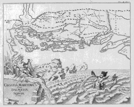
Original title: Croatia Maritima cum Dalmatiae et Serviae Parte
Publishing year: 1748
Place of publishing and publisher: Wien / Nürnberg
Format: 29 x 36 cm
Technique: Copper engraving
The map whose original title reads "Croatia maritima, Dalmatiae pars et pars Serviae" depicts Croatia in the late Middle Ages. On the map, Dalmatian Croatia, before the Turkish occupation of Bosnia, reaches deep in the interior and its northern border follows the mountain ridge of Plješivica, Osječenica and Klekovača. The entire lower half of the map features a spectacular view of the Adriatic Sea with a mermaid and river ridge with a symbolic mythical creature reminiscent of Neptune.
MONATH, PETER CONRAD
MONATH, PETER CONRAD (1682-1747), a polyhistorian, cartographer and publisher from Nuremberg, who later moved to Vienna. He specialized in the works of astronomy and mathematics. Together with Johann Gabriel Doppelmayr and Johann Georg Puschner, he also sold globes in the Vienna branch of his bookstore. His most well-known works are Grundriss Belgrad from 1717 and Dalmatien from 1718.
