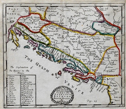
MORDEN, ROBERT: MAP OF SLAVONIA; CROATIA, DALMATIA, BOSNIA AND THE REPUBLIK OF DUBROVNIK
Inventory number 377
Author: MORDEN, ROBERT
Original title: A new map of Sclavonia, Croatia, Dalmatia, Bosnia et. Repub. Ragusa
Publishing year: 1690
Place of publishing and publisher: London
Format: 12,5 x 14,5
Technique: Copper engraving with coloured boundaries
A small map of the entire territory of today's Croatia, Bosnia and Kosovo probably comes from a pocket atlas. London cartographer and publisher Morden was known for representations of small geographic areas and he also issued playing cards with geographic motifs. The boundaries on the map are drawn very arbitrarily, so that Zagreb, for example, remained outside the borders of a very reduced Croatia. It is interesting that the Primorje area from Rijeka to the end of the Velebit Channel is called Morlakia, which became world famous only after Fortis's description 80 years later.
MORDEN, ROBERT
MORDEN, ROBERT, a publisher, bookseller and cartographer from the second half of the 17th century from London, who died in 1703. His most well-known works are Atlas Terrestris from 1695, Sea Atlas from 1699 and various individual large-scale maps. He was particularly well-known for his small maps for pocket-sized atlases. He even used geographical motifs to decorate playing cards he published. He was known for his rather arbitrary marking of borders, including his maps of the Croatian territories. For instance, on his map of central Croatia from 1708 without the Istrian Peninsula, he imprecisely marked the borders defined by the Treaty of Karlowitz (1699), particularly in Dalmatia.
