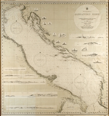
MARDEŠIĆ, PETAR: ADRIATIC SEA
This nautical chart of the Adriatic, distributed by the Hydrographic Office of the Royal Navy in Split and the Naval Arsenal Command in Tivat, brings several bathymetric and hypsometric data. Three compass roses, each with 72 segments, are in the north, middle and south Adriatic. Sea depth is marked in meters every ten meters along the shore. Publisher and distributer data are written on the top edge of the map, with the price of 20 dinars. Istria and Dalmatia within the Kingdom of Yugoslavia after the First World War are depicted, although the political boundaries are not drawn. From the shipping lines, they were drawn from Boka Kotorska towards Bari and Brindisi, while the northernmost of them there are no marked naval routes. The round cartouche with the title of the chart is in the top right corner. In addition to the headline data, the cartouche states that the chart was made by Ship-of-the-line lieutenant of the 1st class A. Petar Mardešić at the scale of 1:1 000 000 in accordance with the Royal Navy's Hydrographic Office measurements and by using "foreign data". Due to the theme of this chart, there are no geographic data on the Apennine Peninsula on the eastern Adriatic hinterland, except for relief hatching and hipsometric data in the narrowest coastal area. The exception is the schematic representation of vertical sections of certain panoramic images or geological-morphological sites (e.g. Otranto Cape, Island of Sazen (today Sazan in Albanian), Svetac, Jabuka, Glavat, Palagruža) and objects (lighthouses from Spas in Kvarner to Stončica in south), with elevation marks. The chart is specific for its (semi)circles of strategic lighthouse sightings, which were of paramount importance for safe navigation. The lighthouses with inserted sketches are: Spas, Sv. Ivan Otočki, Porer, Galijola, Veli Rat, Sestrice, Blitvenica, Mule, Stončica and Fano in Otranto. Geographic coordinates are marked along the chart frame.
MARDEŠIĆ, PETAR
