MORTIER, PIERRE: VENETIAN ISTRIA AND DALMATIA WITH NEIGHBOURING LANDS
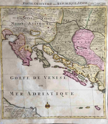
The map shows Venetian properties (Partie Orientale de la Republique de Venise) on the eastern coast of the Adriatic (Istria and Dalmatia) to Šibenik (Sebenico) in the southeast. In addition, although it is omitted in the title of the map, it also introduces a thematic element of military-political demarcation with the Ottomans in the interior of the land before establishment of the Treaty of Srijemski Karlovci border in 1699. There were only a few maps known showing Slavonian and Croatian territories at that time. Larger maps of Hungarian states were rare, because these two provinces were considered a part of the Hungarian Crown. Both Austrian and Dutch authors (Sanson, de Wit, Jaillot) were based on a strategic justification that the Austrian and / or Hungarian states should secure the defenses of these territories from the Ottoman invaders who were at that time stopped in further penetration into the West. An example is the Mortier map of the Hungarian states from 1702, published in his atlas Le theater de la guerre in Amsterdam with the intent of presenting war operations against the Ottomans before The Treaty of Srijemski Karlovci. He also worked on smaller maps of such fortifications, like those of Zadar or the 17th century Vrana. That is why this map of the coastline brings valuable strategic information that Mortier communicated to his audience. With the colour and the border, he separated the so-called Turkish Croatia as a property between Una and Vrbas under the Ottomans, and a similar border was also found in Slavonia. Although somewhat altered, the border between Venice and Habsburg (Confins des Etats de la Maison de Autriche) was recorded in Istria. The classic Mercator influence is evident in the repetition of a mistake in marking the "double" Zagreb (Agram and Zagrabia near Sisak (Sissaken)). Orientation is provided by a compass rose. Geographic coordiantes are in the map frame, and the title and the graphic scales expressed in the four measuring units are located above the upper edge of the map.
MORTIER, PIERRE
