MONATH, PETER CONRAD: MAP OF DALMATIUA AND NEIGHBOURING LANDS
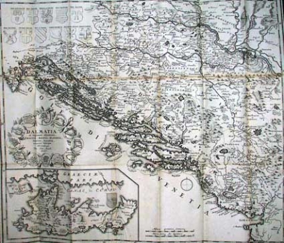
This map was published in the book of travels of Ivan Lučić “Gruendliche Beschreibung des Koenigreichs Dalmatien” printed at Peter Konrad Monath's in Nürnberg in 1723. The book of travels comprises several cartographic representations among them a map of Dalmatia and the surrounding countries as well as several Dalmatian town and island views. The map of Dalmatia and the surrounding countries by Monarth comprises almost all of the Croatian lands: Istraia, Dalmatia, Slavonia and Croatia south of the river Kupa. The representation of the northern part of Croatia is covered by the heraldic symbols drawn in the upper left corner of the map. The illustration contains the coats of arms of the Kingdom of Dalmatia, the Kingdom of Serbia, of Stefan Prvovenčani (first-crowned king of Serbia), the Kingdom of Croatia, the Kingdom of Raška, the Kingdom of Bosnia, the Despotdom of Serbia, of the Herzeg (duke) Stjepana Vukčića as well as those of the Balš-es and Črnojević-es, Dukes of Hum. The map contains serious geographical misinformation, especially as far as the outline of boundaries and administrative-territorial organization is concerned. So, for example the “Ducatus Lezinae Confinia” is shown which as a real duchy never existed. The counties within the territory of Slavonia, shown in their medieval outlines, are also largely misrepresented. The title of the map is in its lower left corner surrounded by the town plans of: Senj, Šibenik, Split, Budva, Korčula, Kotor, Ulcinj, Bar, Dubrovnik, Hvar, Trogir and Zadar. From the way of representing certain geographic details and inaccuracies present on the map in particular with regard to the depiction of the title cartouche it is obvious that the map was inspired by Coronelli’s maps (a title cartouche made up from almost the same town plans we can see on the map of the Adriatic Sea made by Coronelli, and the same district boundaries on the map of the Kingdom of Dalmatia by Nolin – Coronelli). In the lower left corner an inset map of Corfu is added.
MONATH, PETER CONRAD
