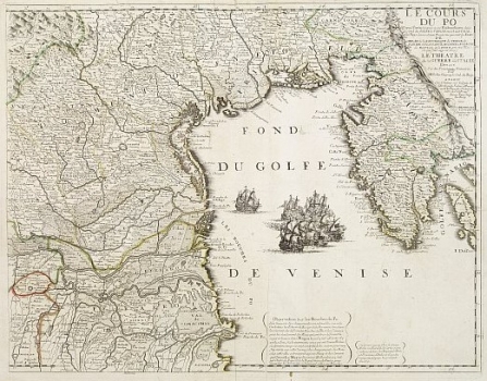
MAP OF THE PO VALLEY, VENICE AND ISTRIA
Inventory number 551
Original title: Le Cours du Po Depuis Turin jusques a ses Embouchures..., part droite
Publishing year: 1702 - 1703
Place of publishing and publisher: Paris
Format: 61 x 48, cm
Technique: Partially coloured copper engraving
The map shows the Po Valley (Les Bouches du Po), the Venetian Lagoon with the Serenissima possessions, the Gulf of Trieste and the entire Istrian Peninsula, as indicated in the title cartouche in the upper right corner (Le Cours du Po Depuis Turin jusques a ses Embouchures). The hoisted sails of the sailing ships in the northern Adriatic evoke the war tensions of the early 18th century, primarily because of the great conflicts between the Venetians and the Ottomans on the eastern Adriatic coast. The Venetian Terra ferma in the hinterland of the City itself is particularly rich in data. The coloured border line between the Venetian and Austrian possessions (Pazin Shire) in the interior of Istria is interesting, and the author was obviously familiar with it. The relief dynamics of Učka and Ćićarija were also known to the author, either from personal knowledge or from the quality templates he used. Moreover, the physical and social geographical inventory shows a much more balanced selection and respresentation compaired to similar maps of the same area by Camocio, Coppo, Bertelli or Pinargenti. The map is almost identical, though much richer in cartographic content, with a 1705 map by the same author. (inv. no. 572 in the Felbar Collection). Among the various other details, this version does not have a compass rose, but it is distinguished by the narrative description of the observations of travellers who travelled through the Po Valley.
ORTELIUS, ABRAHAM
BRAHAM ORTELIUS (1527-1598), a 16th-century geographer and cartographer from Antwerp. He is the foremost Dutch cartographer of all times. After he studied engraving and cartography techniques, for a while he had made a living as a map illustrator. Yet, he made relatively small number of maps of his own. Today, only five maps are firmly recognized as personally drawn by him. The significance of Ortelius' work resides primarily in his efficiency at collecting of cartographic materials and in his atlas-making activities. Up to the year 1570 he gathered 70 maps, that he bound to form a book of the "Theatrum Orbis Terrarum", considered the world's first atlas in the modern sense. His atlas consisted of the maps produced by him or by other cartographers drawn upon various sources. On each map Ortelius identified the author of the map used as model, or the source the map was based upon. To the maps of the "Theatrum" the "Catalogus Auctorum" was appended, which is a list with the names of the cartographers known to him (87 names) and their works. Ortelius' atlas drew a great attention comparable only to the success that had Ptolemy's Geography. The "Theatrum Orbis Terrarum" went through 41 editions. How great Ortelius' reputation established by the success of his atlas was, can be seen from the fact that in 1575 he was designated royal geographer of Phillip II of Spain. Likewise Ptolemy's work, the "Theatrum" was enlarged in subsequent years trough the addition of new maps (the Additamenta").