ORTELIUS, ABRAHAM: ILLYRICUM
Inventory number 41
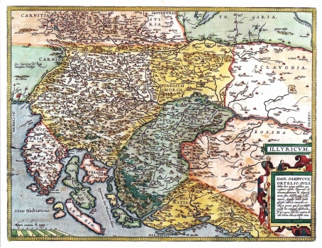
Original title: Illyricum
Publishing year: 1603
Place of publishing and publisher: Amsterdam
Format: 37 x 48 cm
Technique: Coloured copper engraving
Isztvan Zsambok (1531-1584), a Hungarian cartographer best known under its Latin name of Johannes Sambucus made this map for Ortelius' atlas. As regards the Croatian lands, the map shows Croatia, Slavonia, Istria and parts of Dalmatia more or less in accordance with the state before the Turkish invasions. In his map, Sambucus included much of the content from the Hirschvogel's map of Slavonia and Croatia. Especially interesting is the map image of the mount Velebit featured very artfully whit its forested continental slopes differentiated from the bare mountainsides of the coastal area. The lower right corner Renaissance cartouche contains the following dedication text and dating: "Ioan Sambucus Orteliio suo, s< alutem> Mitto hanc quoque tabellam qua nesessaria confinia Pannoniae declarantur; fluviorum et aliquot locorum situs Hirschvogelii haec coniungat desiderarit. Si qui ewrrores sint, dies certiora doceit. Viennae. Vale 25. Octob 1572". A mileage scale shown in the lower left corner is in common and great miles (Milliaria communia & magna).
ORTELIUS, ABRAHAM
BRAHAM ORTELIUS (1527-1598), a 16th-century geographer and cartographer from Antwerp. He is the foremost Dutch cartographer of all times. After he studied engraving and cartography techniques, for a while he had made a living as a map illustrator. Yet, he made relatively small number of maps of his own. Today, only five maps are firmly recognized as personally drawn by him. The significance of Ortelius' work resides primarily in his efficiency at collecting of cartographic materials and in his atlas-making activities. Up to the year 1570 he gathered 70 maps, that he bound to form a book of the "Theatrum Orbis Terrarum", considered the world's first atlas in the modern sense. His atlas consisted of the maps produced by him or by other cartographers drawn upon various sources. On each map Ortelius identified the author of the map used as model, or the source the map was based upon. To the maps of the "Theatrum" the "Catalogus Auctorum" was appended, which is a list with the names of the cartographers known to him (87 names) and their works. Ortelius' atlas drew a great attention comparable only to the success that had Ptolemy's Geography. The "Theatrum Orbis Terrarum" went through 41 editions. How great Ortelius' reputation established by the success of his atlas was, can be seen from the fact that in 1575 he was designated royal geographer of Phillip II of Spain. Likewise Ptolemy's work, the "Theatrum" was enlarged in subsequent years trough the addition of new maps (the Additamenta").