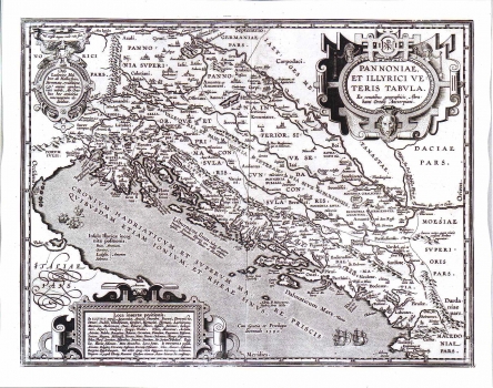
ORTELIUS, ABRAHAM: MAP OF PANNONIA AND ILLYRICUM
This is one of the historical maps representing the ancient times outline of the provinces of Pannonia and Illyricum designed by Abraham Ortelius upon antique sources. It shows the Roman Illyricum with administrative unit boundaries delineation as established by the emperor Diocletian in occasion of his reorganization of the Empire of 297. The annotations made by Ortelius reveal his recourse dating back to Antiquity: Strabon, Pliny and Antoninus. The list of localities that he identified in the written sources, but couldn't locate in the space is shown in the map's margin. The ancient names of various settlements are given, together with a number of ethnic names of various Illyrian tribes that inhabited the area: Seretes, Taurisci, Serapilli, Andiantes, Scordisci, Amantini. On the Adriatic coast are indicated the following place and ethnic names: Iapydes, Mazei et Mezai, Lopsi, Derriopes, Collentini, Varubari, Derrij, Tariotae, Phrygi, Epetini, Ceraunij, Kaurij, Comenij, Piguntiae, Onaei, Piraei, Narinsij, Enderudini, Daorsi et Daursij, Vardei qui et Ardei et forte Varalij, Sardiote, Siculotae, Docleatae, Bulimei, Labaetes, Pirustae i Scritones. The title is shown in a Renaissance cartouche with masquerons in the upper right corner of the map.
ORTELIUS, ABRAHAM
