ORTELIUS, ABRAHAM: DUCHIES OF CARNIOLA AND GORICA, ZADAR AND ISTRIA
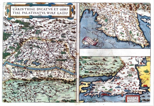
The map of the duchy of Carniola and of the palatinate of Gorica was issued on the same sheet with Kopić's map of Istria and Kolunić's map of Zadar and Šibenik inland area. In the center of the map is shown the upper part of the flow of the river Drava. In Carniola and Gorica all major settlements are indicated. Especially impressive is the representation of the glacial lakes to the north of the river Drau. Namely, three of them are named: Wörther See, Ossiacher See and Millstätter See. Although, the topography is shown, according to the achievements of the time, with longitudinal groups of molehills, mountain ranges of the Karavanke and the Julian Alps can be clearly recognized.
The re-drawn issue of the map of Istria by Petar Kopić published in 1588 edition of Ortelius' "Theatrum Orbis Terrarum". Petar Kopić, native of Istria (1470-1556) from Izola, in his early ears he has been strongly influenced by the Venetian cartographic traditions. He had his schooling in Venice at Marco Antonio Sabelic's workshop. He continued to work in Italy as he was designated Commissioner for Istria of the Venetian Senate. He made this map in 1525 in occasion of one of his official visits to Istria. It was first published in Kopić's atlas "De summa totius orbis". This was the first regional map of Istria that during the 16th and 17th centuries went through many editions. Kopić's map of Istria became, after it has been included in Ortelius' atlas "Theatrum Orbis Terrarum" one of the most frequently issued maps of the Croatian lands of the 16th century. Compared to its first edition, this Kopić's map of Istria is reduced in its geographical content. Namely, due to its smaller format, the number of toponyms is reduced. Also, the categorization of settlements set out in the first edition of Kopić's map is left out. A double line indicates the flows of Dragonja, Mirna, Raša, and of the Channel of Lim made far too elongated and incorrectly orientated. The topography is shown with shaded molehills. Ćićarija is designated as "Monti dela Vena", and Učka as "Monte Mazor". Rijeka is wrongly located on the northeastern coast of Istria, while Bakar and Senj are drawn at the bottom of the Gulf of Kvarner.
The map of Zadar and Šibenik inland area published in the "Theatrum Orbis Terrarum" by Ortelius, is a revised issue of the original map drawn by Martin Rota Kolunić in 1570. This map showing a part of the Dalmatian hinterland was made at the time when this area was the field of decisive battles for Dalmatia. The original author was Martin Rota Kolunić of Šibenik (1532-1583), a respected graphic artist, painter and cartographer. This map was prepared to be edited in Orelius' atlas by Kolunić's contemporary and con-citizen, Božo Bonifačić (1537-1592), also renowned graphic artist and cartographer. The map shows the inland area between the rivers of Krka and Zrmanja with the town of Zadar in its center, as the key Venetian stronghold of defense of Dalmatia against Turks, with parts of Lika and Krbava and the channel of Velebit (Morlacha).
ORTELIUS, ABRAHAM
