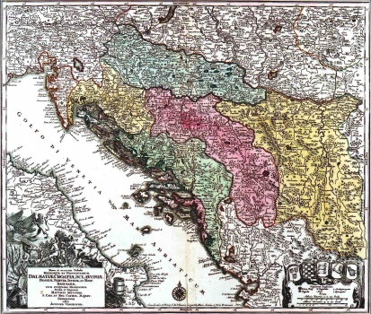
SEUTTER, GEORG MATTHÄUS: MAP OF DALMATIA, CROATIA, SLAVONIA, BOSNIA, SERBIA AND ISTRIA
Inventory number 74
Author: SEUTTER, GEORG MATTHÄUS
Original title: Nova et Accurata Tabula Regnorum et Provinciarum Dalmatiae, Croatiae, Sclavoniae, Bosniae, Serviae, Istriae et Republicae Ragusanae, cum finitimis regionibus Studio et Impensis Matthaei Seutteri Sacrae Caesareae et Regacrae Catholicae Maisestatis geographi edita Augustae Vindelicorum
Publishing year: 1709
Place of publishing and publisher: Augsburg
Format: 50 x 58,2 cm
Technique: Coloured copper engraving
This map shows Slavonia and Croatia outlined within their medieval borders, and Dalmatia with the whole Herzegovina and a part of Montenegro included within its territory in accordance with Venetian sources used. On the Slavonic territory the medieval counties and some towns with their respective area are shown. In the lower right corner are the coats of arms of Dalmatia, Croatia, Slavonia, Bosnia (Rama) and Serbia. The title of the map is placed within a simple rectangle box surrounded with military symbols and allegoric figures. A mileage key is in German miles (Milliaria Germanica) and in Hungarian miles (Milliaria Hungarica).
SEUTTER, GEORG MATTHÄUS
GEORG MATTHÄUS SEUTTER (1678-1757), A German cartographer, geographer and map editor. He was Johann Baptist Homann's disciple, and later the greatest Homann successor's competitor. As graphic artist he started its work in Augsburg. Seutter engraved most of his maps by himself, while for their decoration other artists were entrusted, who in many cases left their signature next to the illustrations made. Seutter's workshop produced about 500 maps. Although these maps are very similar to those issued by Homann they have never reached its outstanding artistic level. The most famous Seutter's works are "Atlas Geographicus", 1725, "Atlas novus indicibus instructus" published in Vienna in 1730, "Grosser Atlas", 1734 and "Atlas monor praecipua orbis terrarum imperia" of 1744.
