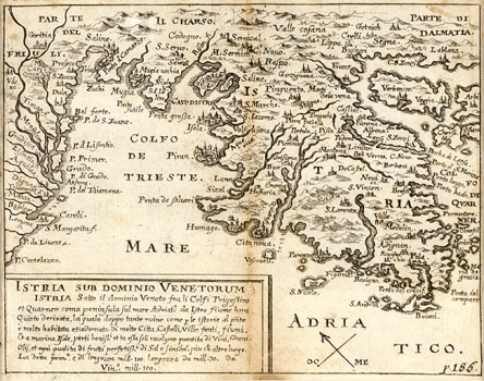
SANDRART, JACOB VON DE: MAP OF ISTRIA
Sandrat's map of Istria was modelled upon the well-known map of Istria made in 1620 by the Venetian cartographer Antonio Magini. As it bears the pagination number 186, it was most likely included in some of the Dutch atlases published in the last years of the 17th century. The influence of Magini on this Sandrat’s map is not reflected only in the way he modelled the seashore contours, but also in the way he featured major towns represented in small very schematic views. We can see, rendered in such a manner, the towns of Izola, Piran, Poreč, Novigrad, Rovinj and Pula. The representation of the western Kvarner area on Sandrat’s map not covered by the map by Magini is considerably less successful. The representation of the island of Krk contains many inaccuracies, and one of its most ancient settlements, Vrbnik, is wrongly placed in the island’s southwest coast.
SANDRART, JACOB VON DE
