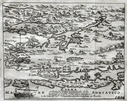
SANDRART, JACOB VON DE: MAP OF ZADAR AND SURROUNDING COUNTRYSIDE
The map shows Zadar’s immediate countryside, the scene of many battles against the Turks. This map was derived from the map of Zadar and Šibenik hinterland made around 1570 by Martin Rota Kolunić. It was produced during the period of the Cypriote war, Kolunić’s maps were a rare cartographic sources relating to the Dalmatian hinterland, one of the principal battlefields of the Venetian-Turkish war. The dotted line marks the Venetian-Turkish border in Dalmatia around 1570. The representation of settlements, especially Zadar as the most important Venetian fortification in Dalmatia, is dominated by the illustration of fortification structures, towers and defence walls. Other major fortifications in Zadar’s hinterland are represented in a similar way. In the waterfront, we can see a Venetian warship, illustrating the atmosphere of Venetian-Turkish wars in which that map was created. Close to Zadar appears the inscription stating that that town was the capital of Dalmatia ruled by the Republic of Venetia. The relief is shown arbitrarily, with shaded molehills. Apart from focusing on the representation of fortification power of settlements, the author placed a special emphasis on the representation of the confluence of the river Zrmanja with the sea. Especially interesting is the representation of the bridge across the river Zrmanja near Obrovac.
SANDRART, JACOB VON DE
