SANDRART, JACOB VON DE: MAP OF SPLIT AND ITS SURROUNDINGS
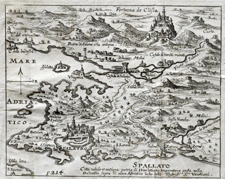
This map of Split and its surroundings was based on the famous view by Božo Bonifačić published in Rosacco’s and Camoco’s isolario. The map shows Split with Solin and Klis in the background. Split is shown enclosed by the walls within which the cathedral of St. Doimo can be seen. Along the bay of Kaštela the ruins of the antique Salona are depicted (Salona citta antiqua ruinata) from where the road leads to the fortress of Klis (Fortezza de Clisa) and its suburb (Brogo). In 1537, Klis was under Turkish rule. That’s why, besides by the fortification structures the representation of the town is dominated by the mosque and its minaret. The massifs of Kozjak and Mosor are illustrated schematically. Around Klis we can see the rests of ravaged structures as document of massive war devastations. Along the river Jadro (Salona f) Castelo di Salona, water mills on the river and one Turkish castle in ruins (Castelo did turchi ruinaro) are shown. There is an annotation next to the town of Split indicating that it comes to an antique town, seat of the Emperor Diocletian and an important port at the time of this map when the town was under the rule of the Republic of Venetia.
SANDRART, JACOB VON DE
