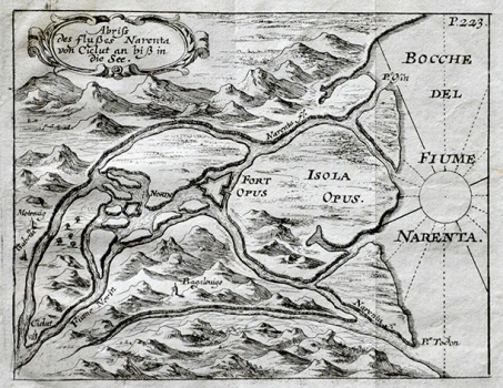
SANDRART, JACOB VON DE: MAP OF THE CONFLUENCE OF THE RIVER NERETVA WITH THE SEA
This Sandrart’s map shows the delta-shaped confluence of the river Neretva with the sea. The attention of the author was focused on the depiction of the river’s backwaters and on the representation of the fort Opus that had a key role in the defence of south Dalmatia during the period of Venetian-Turkish wars. In the Opus’s hinterland the fort built at the confluence of the Norin and Neretva rivers and places of Čitluk and Gabela can be seen. At the time of the creation of this map this area was under Turkish rule. After 1684 the Neretva borderland came under the rule of Venetians (The fort Norin was definitely conquered by the Venetians in 1688 and Čitluk (Gabelu) not earlier than in 1694). In the network of backwaters of the Neretva river islets can be seen out of which some bigger in size are designated with names – the biggest among them is the islet Opus (Isola Opus) and the islet of Osinj (Osin) at that time belonging to the monastery of Zaostrog. The relief is shown using the method of shaded molehills. The title of the map is at top left in an ornate cartouche. Some ten years later, after Venetians re-conquered the area Vincenzo Maria Coronelli produced a similar map.
SANDRART, JACOB VON DE
