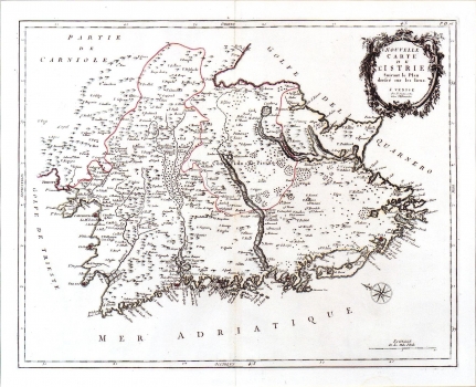
SANTINI, PIETRO: MAP OF ISTRIA
Inventory number 93
Author: SANTINI, PIETRO
Original title: Nouvelle Carte de l’ Istrie Suivant le Plan dresse sur les lieux
Publishing year: 1790
Place of publishing and publisher: Venise
Format: 45,5 x 57 cm
Technique: Copper engraving
Santini was author and publisher of this map of Istria that was issued in his work "Atlas Universel" published in Venice. This map is based on a similar map of Istria issued by Giovani Salmon in 1753 in his work "Lo stato presente di tutti i paesi e popoli del mondo" printed at Albrizzi in Venice in 1753. It differs from the model map only by its graphical design. The boundaries of the county of Pazin and the boundary lines between the Venetian Istria and Carniola are indicated. The topography is shown with shaded molehills and a tree symbol is used to represent the vegetation. The title is shown in the upper right corner in a rococo cartouche. A mileage scale is in Italian miles (Miglia d'Italia).
SANTINI, PIETRO
SANTINI, PIETRO – a Venetian cartographer and publisher who was active during the second half of the 18th century in Venice. He created several well-known maps of Istria and Dalmatia. His most well-known works are Atlas Universel, published in Venice in 1776 and 1783, and Atlas Portatif, published in 1782.
