SANSON, NICOLAS: MAP OF DALMATIA
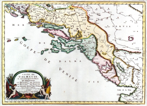
This Sanson's map was issued in his atlas of 1664. It shows the whole Venetian Dalmatia and the Republic of Dubrovnik. The borders, especially the northern ones are not accurate. The influence of Venetian maps is obvious as these regularly included Herzegovina within the Dalmatian borders as it was the zone of their interest. Coastal and insular profiles are quite accurate. Between the rivers Cetina and Neretva two in-existent river islands are depicted. The continental part of the Venetian Dalmatia is colored yellow, and the Republic of Dubrovnik green. The respectively belonging islands are not colored following the same logic, so, the islands of Korčula and Brač that at the time were making part of the Republic of Venice are colored green. The territory around Bocche di Cattaro is colored in pink although in the time of production of this map it was under Turkish administration (it passed under Venetian control only in 1700 i.e. in 1730). Landforms are not represented. The title is shown in the lower left corner in a baroque cartouche decorated with cherubs and military symbols. To the left of the cartouche the engraver left his signature: Lhuiler fe. The text placed below the cartouche explains that the settlements inhabited by Christians are indicated with a cross, and those having Muslim population with a crescent.
SANSON, NICOLAS
