ROSACCIO, GIUSEPPE: VIEW OF PULA
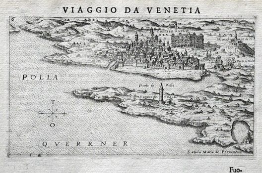
This copperplate map image was made during the period of stagnation in the development of the town of Pula occurred at the beginning of the early New ages. The author drew Pula as a rather small densely built town. Walls on the seaward side protest the town. In the background ruins of an antique amphitheatre (ccoloseo antico) are identified, as well as the monastery with St. Michael church. In front of the church the rests of antique buildings (ruine antiche) are shown. The Golf of Pula is shown with many inaccuracies as well as the southern peninsula in front of Pula on which the turret of Orlando is identified and the Church of St. Mary of Premantura. This Rosaccio’s view comes from the first edition of his travel-record book «Viaggio da Venetia a Constantinopoli per Mare, e per Terra, & insieme quello di Terra Santa» published in 1598. It seems likely that Rosaccio based his map on the view produced by Božo Bonifačić in 1571 for Comoco’s isolario.
ROSACCIO, GIUSEPPE
