ROSACCIO, GIUSEPPE: VIEW OF OSOR ON THE ISLAND CRES
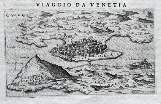
Rosaccio’s view shows Osor on the island of Cres, after the last attempt of its reconstruction made during the 15th century. At the time of the production of this map the number of its inhabitants was drastically diminishing and the place counted only 500 of them. Simultaneously with drastic decrease in number of inhabitants more and more houses ware abandoned and the town gradually retreated into its ancient nucleus. That resulted in a partial destruction of the city walls occurred in 15th century and in the construction of new houses and the eastern part of the town together with the St. Mary’s cathedral found itself outside walls. On Rosaccio’s view narrowed dimensions of the town of Osor are clearly shown, as well as its old cathedral outside city walls and the Franciscan monastery founded in area of Bijar founded in 1465. This intensive construction work gives evidence of a huge effort made by the citizens of Osor to hold out despite the loss of all significant functions the town previously had. Unfortunately, all they tried was not enough to stop the process of general decay of this noted town. This Rosaccio’s view was published in the first edition of his travel-record book «Viaggio da Venetia a Constantinopoli per Mare, e per Terra, & insieme quello di Terra Santa» of 1598. Rosaccio drew on Božo Bonifačić’s map made in 1571 for Comocio’s isolario as his source.
ROSACCIO, GIUSEPPE
