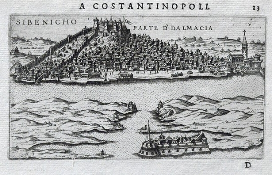
ROSACCIO, GIUSEPPE: VIEW OF ŠIBENIK
This view shows the town of Šibenik identical to the drawn by Martin Rota Kolunić a native of Šibenik for the famous isolario by Francesco Camocio published in 1571. His view image of Šibenik is considered to be the most accurate representation of any Croatian town made during the Renaissance period. In the foreground, we can see the castle of St. Nicola very artfully featured, as well as two smaller bastions that controlled the entrance into the Šibenik channel. The view image is dominated by the representation of the fort above the town (Castelo). From the castle the town’s defence walls, inner and outer, descend towards the sea. Within the land laying between the two rings of walls only a few structures were built and it seems likely that the soil was used for cultivation (fertile inland zone was occupied by the Turks!). Some of the town’s characteristic palaces and its cathedral can be also recognized. The eastern part of the town reaches up to St. Francis monastery. By highlighting Šibenik’s topographic position on top of a hill providing good sight on the surrounding area, as well as putting emphasis on its castles, ramparts and sea bastions, he created impression of a great defensive power and impregnability of Šibenik, one of the key strongholds in the line of defense against Turks. This view comes from the first edition of Rosaccio’s travel-record book «Viaggio da Venetia a Constantinopoli per Mare, e per Terra, & insieme quello di Terra Santa» published in 1598.
ROSACCIO, GIUSEPPE
