ROSACCIO, GIUSEPPE: VIEW OF TROGIR
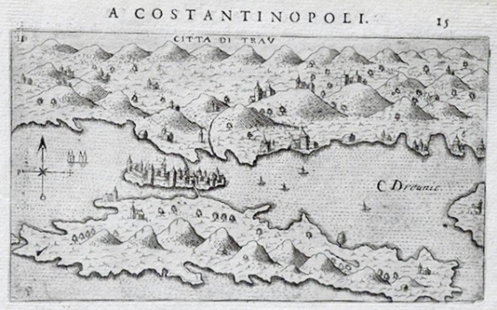
This view of Trogir is one of the better came out from among the views included in Rosaccio’s travel-record book. In the foreground the island of Čiovo and the town of Trogir with its surroundings can be seen. Graphically, this view represents a masterpiece with a wealth of information included. The island of Čiovo is shown as uninhabited with only a few churches. The town of Trogir is shown as seen from the southern side. From the continent, the access to the town was possible across the bridge by which it was connected with the island of Čiovo. The town is encircled with massive ramparts provided with towers. Within the space enclosed by the walls the fort Kamerlengo, the tower of St. Mark, the cathedral and belfry of the Benedictine church of St. Johan are featured. To the east of the town the string of villages of Kaštela (Castel Stafileo, Cipico Nouo, Casaceg, Cipiso Vechio, Casa Rosalina i Vichos) is shown. In the inland zone of Trogir there is a fertile basin of Radošić polje. This Rosaccio’s view appeared in the first edition of his travel-record book «Viaggio da Venetia a Constantinopoli per Mare, e per Terra, & insieme quello di Terra Santa» dated 1598. Rosacico derived his representation of Trogir from the 1571 Božo Bonifačić’s view made for Comocio’s isolario.
ROSACCIO, GIUSEPPE
