RENNER, FRIEDRICK CONRAD: CROATIA, HERCEGOVINA, BOSNIA, SERBIA AND MONTENEGRO
Inventory number 386
Author: RENNER, FRIEDRICK CONRAD
Original title: Die Europ. Turkei: Croatien, Herzegovina, Serbien, Bosnien und das Land der Montenegrinen
Publishing year: 386
Place of publishing and publisher: Hildenburghausen
Format: 18,2 x 24 cm
Technique: Steel engraving
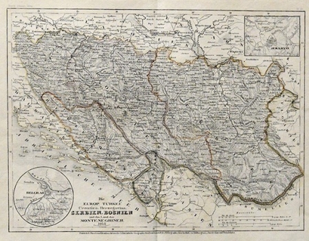
The map of the Ottoman Empire's holdings in Europe comes from probably one of the most popular German atlases of the 19th century, "Meyer's Zeitungs-Atlas", printed in the highly influential Schweinfurter Geographische Gravieranstalt des Bibliographischen Institut with subsidiaries in Amsterdam and Philadelphia (USA). The map with shading shows the final range of the Ottoman Empire to the Glina River. Montenegro, which was never completely occupied, is also shaded. the location of Belgrade is shown in a separate box in the lower left corner, and the location of Sarajevo is indicated on the right-hand side.
RENNER, FRIEDRICK CONRAD
RENNER, FRIEDRICK CONRAD lieutenant (most productive from 1841 to 1852), an engineer who worked on the hydrographic survey of the Sava River from 1729 to 1735. This resulted in the first comprehensive map of the entire Sava River in a scale of 1:270 000. His most significant work is Atlas Hildburghausen from 1841. He collaborated with Carl Christian Franz Radefeld (1788-1874), including the work on Meyer’s Neuster Universal Atlas Grosse Ocean from 1849. In the same year, Meyer published Neuster Zeitung Atlas Hildburghausen.
